(Part 2, Chapter 9, Section 4) ( Bk. Index )
The following transcript is from the WSRO apportionment.
[Summary of preamble]
Agreement ... 1st Nov 1839 ... confirmed
Provisional Articles of Agreement for the Commutation of the Tithes of that part of the Parish of Angmering ... which is not tithable to the Prebenadry of Ham and Bargham and which has been declared a separate District ... holden by adjournment [1st April 1839] By and Between several ... Owners of Land ...
George Pechell of Castle Goring ... Captain in the R.N. Impropriator of the Great Tithes arising from the Lands within the said District specified in the second and third Schedules hereunto annexed.
The Revd John Usborne Rectorof the said Parish and Owner of the Tithes of the said District except those ... payable to Revd John Hanley as Vicar of Amberley ... and to the said George Richard Pechell ...
Whereas G. R. Pechell is seized of an Estate ... in fee simple in the Great Tithes arising from those Lands of the said District ... in the third Schedule ... of which Lands he is also Owner. Now the said G. R.Pechell hereby declares it to be his Will and Intent ... that the said Great Tithes be ... absolutely merged ... in the Freehold ... of the Lands.
And it is hereby agreed that the annual Sum of £26 ... rent charge ... shall be paid G. R. Pechell instead of the Great Tithes of the lands specified in the 2nd Schedule.
£299 ... paid to John Usborne as Rector ... instead of all other Tithes ... Great and Small ... including the Tithe of Fish ... except the Lands paying Tithes to the Vicar of Amberley and also except the Tithes of the Glebe lands for which ... £15 18s 0d is fixed ...
£8 5s 0d to John Hanley as Vicar of Amblerley instead of all Great Tithes of the Lands in the 4th Schedule
The First Schedule
The whole district contains 3150 acres 0r 36p of Land
subject to tithes of any kind 2878 acres 1r 8p
titheable land ... Arable 795 acres 3r 10p
Meadow or Pasture 493 acres 1r 0p
Wood land 425 acres 1r 25p
Moduses instead of Tithes
£10 to Rector of Angmering in respect of 335 acres 0r 8p and 2 acres 2r 0p together called ... Old and New Place farms belonging to ... Duke of Norfolk; and also in respect of 471 acres 3r 23p Angmering Park Farm also belonging to Duke of Norfolk
The annual sum of £4 to Rector of Angmering in respect of 315 acres 3r 39p called ... Lower Barpham Farm ... belonging to G. R. Pechell.
Exempt from Tithes 45 acres 3r part of Ecclesden Farm ... belonging to George Grant of Angmering Yeoman. 88 acres 3r also part of said Farm ... belonging to Samuel Henty of Kingston by Sea Yeoman. 5 acres 0r 12p part of same Farm belonging to Henry Grant Miller. 137 acres 1r 28p remaining part of Farm belonging to James Grant of Angmering Yeoman ...
The whole of which said Farm ... called Ecclesden ... formerly belongeed to a certain College called Sion College and during the Reign of Hen. VIII were severed from the said College and then declared and ever since ... remained Tithe free.
The Glebe Lands of the said Parish which if not in the hands of the owner would be subject to Tithes 38 acres 1r 35p belonging to John Usborne ...
The Second Schedule ... specifying Lands in the District the Great Tithes belonging to G.R. Pechell and which Tithes are not merged.
12 acres 2r 0p belonging and in the occupation of George Cortis of Angmering Yeoman
47 acres 3r 24p belonging to Duke of Norfolk in occupation John Cole Tompkins
35 acres 1r 37p belonging and in occupation of Jeremiah Lear of Leominster Gent.
27 acres 0r 0p belonging to Jeremiah Lear in occupation of Charles Mills
6 acres 1r 25p belonging and in occupation Nathaniel Sayers
Third Schedule ... Great Tithes belonging to G.R. Pechell ... declared merged.
313 acres 2r 25p in occupation of William Miles
115 acres 3r 21p in occupation of John West Heasman
13 acres 1r 0p in occupation of Charles Stanmer
all [above] belonging to G.R. Pechell
Fourth Schedule ... Great Tithes belonging to John Hanley ...
The Denshire Field 4 acres 3r 6p in occupation James Penfold
The Eight Acres 9 acres 1r 20p
Bread and Cheese Croft 2 acres 3r 10p in occupation William Miles
Gross Rent Charge for the Parish of Angmering £340 3s 0d
Rector £305 18s 0d
Impropriator £26 0s 0d
Vicar of Amberley £8 5s 0d
[end of preamble]
Angmering without Barpham and Ham WSRO: IR/29 35/
Map WSRO: IR/30 35/9 by Henry Salter of Arundel 1839
It should be noted that PRO, and other copies of the tithe maps for Angmering vary in slight detail.
The Parish copy orf the map is deficient in a house [Saddlers] Several plot numbers are deficient or repeated.
RWS 19/3/2009
Angmering Tithing included the central village area, Angmering Park, and Lower Barpham. Upper Barpham and Ham were in a separate tithing.
Angmering proper included the main village centre and former common fields. It included a larger number of small and large farms, and numerous houses which often had crofts or smallholds attached. The principal farms are scheduled in the same general order as in the original 1839 Apportionment, although some gathering together of family holdings into combined schedules minimises the number of schedules and maps.
The fact that a person is named as a tenant of a farm together with its farmstead, does not necessarily mean that he was living there. Only reference to census, and other sources, can confirm actual residency. No comment will be made in this part about who lived where, with ownership and tenancy taken at face value.
In few instances are farms or houses identified in a way that can be understood today. Where modern names are introduced so as to identify properties, it must be understood that the houses that existed in 1839 may have been rebuiilt, or entirely replaced, and it is the location rather than the building itself which is being named. Errors in this are possible and corrections may be needed at a later date. In many instances houses are named that cannot be identified with any particular house today, and these are in italics.
The original schedules have areas in Acres, Roods, and Perches. A rood is1/4 acre. A perch 1/40 of a rood. An antiquated form of measurement that is difficult to use, even without modern metrication. Therefore the areas in these tables are converted to acres and decimal parts. In approximate conversion there are 2 ½ acres to one hectare.
William and Richard Amoore ownership
Ivy Cottage tithe 420 Watertone House 391 Aberdeen House 389 Old Mill House 531
Refer to Map 1 (below)
| Owners | Tenants | Plot |
Acres |
Usage |
Name |
| Amoore Richard | Amoore Richard | 420 |
0.11250 |
house |
House shop outb garden |
| . | . | . |
. |
. | |
| Amoore Sarah | Amoore Mrs Sarah | 391 |
0.21875 |
house |
House outb yard garden |
| . | . | . |
. |
. |
. |
| Amoore William | Amoore William | 184 |
0.71875 |
G |
Inclosed from waste |
| Amoore William | Amoore William | 389 |
0.24375 |
house |
House outbb malthouse yards etc |
| Amoore William | Amoore William | 185 |
0.76250 |
g |
Inclosed from waste |
| Amoore William | Amoore William | 532 |
0.21250 |
mill |
Wind Mill Plat and garden |
| Amoore William | Amoore Richard | 529 |
1.15625 |
g |
Mill Croft |
| Amoore William | Compton etc | 531 |
0.25625 |
houses |
Tenements & gardens |
| . | TOTAL | . |
3.35000 |
. |
. |
MAP 1
Amoore Family
Area directly south of High Street
East of Station Road
William and Richard Amoore tenancies
Houses as named under ownership.
Map 1 (above) and Map 2 (below)
| Owners | Tenants | Plot |
Acres | Usage |
Name |
| Amoore Sarah | Amoore Mrs Sarah | 391 |
0.21875 |
house |
House outb yard garden |
| . | . | . |
. |
. |
. |
| Amoore Richard | Amoore Richard | 420 |
0.11250 |
house |
House shop outb garden |
| Cortis George | Amoore Richard | 443 |
4.05000 |
g |
The Cottrells |
| Amoore William | Amoore Richard | 529 |
1.15625 |
g |
Mill Croft |
| . | . | . |
5.31875 |
. |
.. |
| . | . | . |
. |
. | . |
| Amoore William | Amoore William | 184 |
0.71875 |
G |
Inclosed from waste |
| Amoore William | Amoore William | 185 |
0.76250 |
g |
Inclosed from waste |
| Amoore William | Amoore William | 532 |
0.21250 |
mill |
Wind Mill Plat and garden |
| Amoore William | Amoore William | 389 |
0.24375 |
house |
House outbb malthouse yards etc |
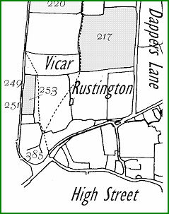
| Rustington Glebe | Amoore William | 217 |
17.28125 |
a |
Stile Field |
| Rustington Glebe | Amoore William | 251 |
0.08125 |
hovel |
Hovel & Yard |
| Rustington Glebe | Amoore William | 253 |
2.55625 |
g |
Malthouse Croft |
| Olders Charity | Amoore William | 520 |
11.84375 |
g |
School Land |
| Olders Charity | Amoore William | 538 |
3.75000 |
g |
School Land |
| . | . | Total | 37.45000 |
. | . |
MAP 2
Amoore Family
Area north of High Street
East of Arundel Road
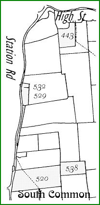
Henry Baker ownership and tenancies
St Margaret’s Cottage 384 Conyers 383 Vestry Cottage 400
Maps 3 and 4 (below)
| Owner | Plot | Acres | Sub Tot | Usage |
Name |
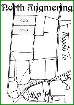
| Angmering Glebe | 220 | 6.01875 | . | a |
Lower Down Furlong |
| Angmering Glebe | 222 | 6.71875 | . | a |
Upper Down Furlong |
| Angmering Glebe | 534 | 18.71875 | . | a |
Glebe Field |
| Angmering Glebe | . | . | 31.45625 | . |
. |
| Baker Henry | 376 | 3.5875 | . | g |
The Conyers |
| Baker Henry | 384 | 0.05625 | . | houses |
Tenements & Yard [occ by cottagers] |
| Baker Henry | 381 | 0.25 | . | garden |
Garden |
| Baker Henry | 383 | 0.1 | . | house |
House outbs |
| Baker Henry | 400 | 0.04375 | . | candles |
Candle Manufactury |
| Baker Henry | . | 4.0375 | . |
. | |
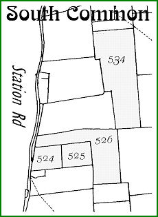
| Gratwicke WGK | 526 | 11.8625 | . | a |
Dell Field |
| Olders Charity | 524 | 3.8125 | . | g |
School Land |
| Olders Charity | 525 | 4.09375 | . | g |
School Land |
| Olders Charity | . | 19.76875 | . |
. | |
| TOTAL | . | 55.2625 | . | . |
. |
| Note: Henry Baker owned no other property than the 4 acres listed above | |||||
MAP 3
Henry Baker
Area north of High Street
East of Arundel Road
MAP 4
Henry Baker
Area south of High Street
East of Station Road
Deborah Boyce owner of Pigeon House
Pigeon House 356 Elmgrove 405
Map 5 (below)
| Owner | Tenant | Plot |
Acres |
Usage |
Name | |||||||
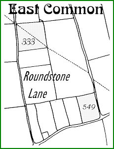
| Boyce Deborah | Standen Thomas | 333 |
8.3188 |
a |
East Common | |||||||
| Boyce Deborah | Standen Thomas | 350 |
0.3750 |
g |
Plat | |||||||
| Boyce Deborah | Standen Thomas | 355 |
0.1875 |
barn |
Barn & Yard | |||||||
| Boyce Deborah | Standen Thomas | 356 |
0.1125 |
house |
House and Garden | |||||||
| Boyce Deborah | Standen Thomas | 357 |
0.1188 |
garden |
Garden | |||||||
| Boyce Deborah | Standen Thomas | 358 |
0.1063 |
garden |
Garden | |||||||
| Boyce Deborah | Standen Thomas | 549 |
5.5500 |
a |
Six Acres | |||||||
| Boyce Deborah | various | 405 |
0.0875 |
houses |
Tenements & gardens | |||||||
| . | TOTAL | . |
14.8563 |
. |
. | |||||||
|
||||||||||||
MAP 5
Deborah Boyce
Area east of Roundstone Lane
North of Worthing Road
George Cortis owner of Wooden Chimney House
Wooden Chimney House 168 Kinnoull 421 Rose Cottage 368 Salters 423 Bennington 427
Old House 429 Weavers Cottage 430 Church House 387 The Rosary 408 Barrack Yard 416
Maps 6 and 7 (below)
| Owner | Tenant | Plot |
Acres |
Usage |
Name |
| Cortis George | Amoore Richard | 443 |
4.0500 |
g |
The Cottrells |
| Cortis George | Carter James | 421 |
0.2563 |
house |
House outbs Garden |
| Cortis George | Carter James | 436 |
2.8375 |
g |
Wind Mill & Mill Plat |
| Cortis George | Carter James | 435 |
0.3438 |
g |
part of Mill Plat |
| Cortis George | Compton etc | 168 |
0.4813 |
house |
Wooden Chimney House & Garden |
| Cortis George | Compton etc | 255 |
0.1500 |
houses |
Two Tenements & Garden |
| Cortis George | Compton etc | 368 |
0.1875 |
houses |
Two Tenements & Garden |
| Cortis George | Compton etc | 388 |
0.1125 |
houses |
Tenements & Gardens |
| Cortis George | Compton etc | 423 |
0.3063 |
house |
House & Garden |
| Cortis George | Compton etc | 427 |
0.1125 |
house |
House & Garden |
| Cortis George | Compton etc | 428 |
0.1250 |
garden |
Garden |
| Cortis George | Compton etc | 429 |
0.2688 |
house |
House outbs yard & garden |
| Cortis George | Compton etc | 430 |
0.0250 |
house |
House & outbuilding |
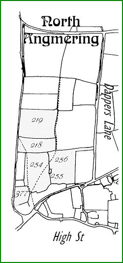
| Cortis George | Cortis George | 218 |
5.9000 |
g |
The Long Lop dells |
| Cortis George | Cortis George | 219 |
11.6250 |
g |
The Upper Lop dells |
| Cortis George | Cortis George | 254 |
10.2500 |
g |
West Church Field |
| Cortis George | Cortis George | 255 |
0.1063 |
hovel |
Hovel & Yard |
| Cortis George | Cortis George | 256 |
10.1250 |
g |
East Church Field |
| Cortis George | Cortis George | 386 |
0.1438 |
garden |
Garden |
| Cortis George | Cortis George | 387 |
0.3000 |
house |
House outbs Yards Gardens |
| Cortis George | Cortis George | 399 |
0.0938 |
barn |
Barn outbs & yard |
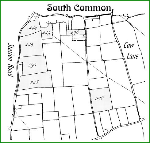
| Cortis George | Cortis George | 445 |
13.9063 |
g |
Upper Mill Field |
| Cortis George | Cortis George | 528 |
13.4188 |
a |
Dell Field |
| Cortis George | Cortis George | 530? |
12.3313 |
g |
Mill Field |
| Cortis George | Cortis George | 546 |
12.5625 |
a |
Round Stone Field |
| Cortis George | Cortis George | 377 |
2.1938 |
g |
House Plat |
| Cortis George | Cortis John | 407 |
0.0813 |
garden |
Garden |
| Cortis George | Cortis John | 408 |
0.3875 |
house |
House outbs Butchers Shop Yard & Garden |
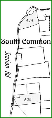
| Cortis George | Cortis John | 444 |
6.0250 |
g |
(nil) |
| Cortis George | Various | 416 |
0.4875 |
houses |
Barrack Yard Cottages & Garden |
| . | . | . | 109.19375 |
. |
. |
| . | . | . | . | . | . |
| Cortis George tenant only of his own land and 92.956 acres as above | |||||
MAP 6
George Cortis
Area north of High Street
East of Arundel Road
MAP 7
George Cortis
Area south of High Street
East of Station Road
John Cortis tenant The Rosery or Rosary
The Rosary 408
Map 8 (below)
| Owners | Tenants | Plot |
Acres |
Usage |
Name |
| Cortis George | Cortis John | 407 |
0.08125 |
garden |
Garden |
| Cortis George | Cortis John | 408 |
0.38750 |
house |
House outbs Butchers Shop Yard garden |
| Cortis George | Cortis John | 444 |
6.02500 |
g |
(nil) |
| Olders Charity | Cortis John | 522 |
8.13750 |
g |
School Land |
| . | TOTAL | . | 14.63125 |
. | . |
MAP 8
John Cortis
Area south of High Street
East of Station Road
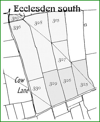
Grant family owners of Ecclesden Manor House
Ecclesden Manor 309 Ecclesden Mill Cottage 314 Commerce house 367 Spotted Cow Inn 345
Maps 9 and 10 (below)
| OWNER | Tenant | Plot |
Acres |
Usage |
Name |
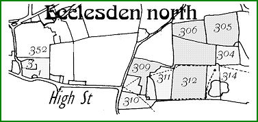
| Grant Henry | Grant Henry | 304 |
2.71875 |
g |
Little Furze Field |
| Grant Henry | Grant Henry | 314 |
2.72500 |
House etc |
Windmill Cottage outbs plat etc |
| . | TOTAL | . |
5.44375 |
. |
. |
| . | . | . |
. |
. |
. |
| Grant James | Grant George | 305 |
5.64375 |
g |
The Upper Furze Field |
| Grant James | Grant George | 306 |
3.23125 |
g |
Lower Furze Field |
| Grant James | Grant George | 309 |
3.30000 |
house |
farm House outbs yards gardens etc |
| Grant James | Grant George | 312 |
6.89375 |
g |
The Great Downs |
| Grant James | Grant George | 313 |
6.14375 |
g |
The Great Furze Field |
| Grant James | Grant George | 315 |
15.87500 |
a |
The Tinkers Field |
| Grant James | Grant George | 327 |
12.48125 |
a |
The Twelve Acres |
| Grant James | Grant George | 328 |
30.80625 |
a |
The Forty Acres |
| Grant James | Grant George | 330 |
15.84375 |
a |
Lower Sixteen Acres |
| Grant James | Grant George | 336 |
31.98125 |
a |
Upper & Middle 16 Acres |
| Grant James | Grant James | 310 |
5.17500 |
g |
The Paddock |
| Grant James | Grant James | 311 |
3.60000 |
g |
The Little Downs |
| Grant James | Grant James | 325 |
15.21875 |
a |
The Strongs Field |
| Grant James | Grant James | 326 |
13.06875 |
a |
The Dell Field |
| Grant James | Grant James | 329 |
15.50000 |
a |
Seventeen Acres |
| Grant James | Bungard Ann | 367 |
0.11875 |
House |
Cottage & Garden |
| . | TOTAL | .. |
184.88125 |
. |
. |
| . | . | . |
. |
. |
. |
| Grant James jun | Grant James jun | 345 |
0.15000 |
house |
House and Garden |
MAP 9
Grant Family
Area east of High Street
MAP 10
Grant Family
Area east of Cow Lane
North of Worthing Road
Grant family tenants
Ecclesden Manor 309 Old House 429 Ecclesden Mill Cottage 314 Wayside Cottage 351
Malt House 353 Spottted Cow 345
Maps 9 and 10 (above)
| Owner | Tenants | Plot |
Acres |
Usage |
Name |
| Grant James | Grant George | 305 |
5.64375 |
g |
The Upper Furze Field |
| Grant James | Grant George | 306 |
3.23125 |
g |
Lower Furze Field |
| Grant James | Grant George | 309 |
3.30000 |
house |
Farm house outbs yards gardens |
| Grant James | Grant George | 312 |
6.89375 |
g |
The Great Downs |
| Grant James | Grant George | 313 |
6.14375 |
g |
The Great Furze Field |
| Grant James | Grant George | 315 |
15.87500 |
a |
The Tinkers Field |
| Grant James | Grant George | 327 |
12.48125 |
a |
The Twelve Acres |
| Grant James | Grant George | 328 |
30.80625 |
a |
The Forty Acres |
| Grant James | Grant George | 330 |
15.84375 |
a |
Lower Sixteen Acres |
| Grant James | Grant George | 336 |
31.98125 |
a |
Upper & Middle 16 Acres |
| Cortis George | Grant George | 428 |
0.12500 |
garden |
Garden |
| Cortis George | Grant George | 429 |
0.26875 |
house |
House outbs yard & garden |
| . | TOTAL | . |
132.59375 |
. |
. |
| Grant Henry | Grant Henry | 304 |
2.71875 |
g |
Little Furze Field |
| Grant Henry | Grant Henry | 314 |
2.72500 |
House etc |
Windmill Cottage outbs plat etc |
| Henty Samuel | Grant Henry | 351 |
0.09375 |
House |
Cottage & garden |
| Henty Samuel | Grant Henry | 352 |
2.66875 |
g |
Croft |
| Henty Samuel | Grant Henry | 353 |
0.61250 |
House |
House Malthouse Yard Garden etc |
| . | TOTAL | . |
8.81875 |
. |
. |
| Grant James | Grant James | 310 |
5.17500 |
g |
The Paddock |
| Grant James | Grant James | 311 |
3.60000 |
g |
The Little Downs |
| Grant James | Grant James | 325 |
15.21875 |
a |
The Strongs Field |
| Grant James | Grant James | 326 |
13.06875 |
a |
The Dell Field |
| Grant james | Grant James | 329 |
15.50000 |
a |
Seventeen Acres |
| . | TOTAL | . |
52.56250 |
. |
. |
| Grant James jun | Grant James jun | 345 |
0.15000 |
house |
. |
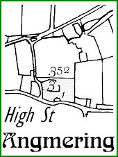
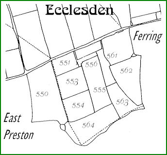
Henty owner Malthouse and Lakes of Ecclesden
Wayside Cottage 351 Malt House 353
Maps 11 and 12 (below)
| Owner | Tenant | Plot |
Acres |
Usage |
Name |
| Henty Samuel | Grant Henry | 351 |
0.09375 |
House |
Cottage & Garden |
| Henty Samuel | Grant Henry | 352 |
2.66875 |
g |
Croft |
| Henty Samuel | Grant Henry | 353 |
0.61250 |
House |
House Malthouse Yard Garden etc |
| Henty Samuel | Henty Samuel | 550 |
18.76875 |
a |
West Lakes |
| Henty Samuel | Henty Samuel | 551 |
4.72500 |
g |
Barn Croft |
| Henty Samuel | Henty Samuel | 552 |
0.44375 |
barn |
Barn outbs yard |
| Henty Samuel | Henty Samuel | 553 |
8.01875 |
a |
Upper Barn Field |
| Henty Samuel | Henty Samuel | 554 |
8.31250 |
a |
Lower Barn Field |
| Henty Samuel | Henty Samuel | 555 |
10.22500 |
a |
Long Lakes |
| Henty Samuel | Henty Samuel | 556 |
0.67500 |
g |
The Drift Road |
| Henty Samuel | Henty Samuel | 561 |
3.54375 |
g |
Rush Lakes |
| Henty Samuel | Henty Samuel | 562 |
12.16875 |
a |
Three Cornered Lakes |
| Henty Samuel | Henty Samuel | 563 |
6.71875 |
g |
Lower Rush Lakes |
| Henty Samuel | Henty Samuel | 564 |
14.03125 |
g |
Dencher Field |
| . | TOTAL | . |
91.00625 |
. |
. |
MAP 11
Samuel Henty
High Street
MAP 12
Samuel Henty
South of Worthing Road
Introduction to Tithes & Commutations
Key Maps
Bargham & Ham Apportionments